Multimedia Gallery
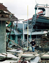
Piles of Debrie, Banda Aceh
Debrie piled 5 meters high in Banda Aceh province in Northern Sumatra, one of the areas hardest hit by the tsunami and earthquake.
This photo was taken by Dr. Jose Borrero of the University of Southern California Tsunami research group. Borrero traveled to various locations throughout Sumatra following the tsunami to collect data and take photographs. Among the places he visited were Lhoknga, Kreung Raya, Panteraja, Lhokkreut, Lhokseumawe and Idi. Travel to these locations was made possible by grants from the Earthquake Engineering Research Institute and the National Science Foundation. Logistical support and support on the ground were made possible by the National Geographic Society.
To learn more about Borrero's trip and read his daily notes, visit his Web page on the Tsunami Research Center Web site. [One of five related images. See Next Image.] (Date of Image: January 2005)
Credit: ©2005 Dr. Jose C. Borrero, USC Tsunami Research Group
Images and other media in the National Science Foundation Multimedia Gallery are available for use in print and electronic material by NSF employees, members of the media, university staff, teachers and the general public. All media in the gallery are intended for personal, educational and nonprofit/non-commercial use only.
Images credited to the National Science Foundation, a federal agency, are in the public domain. The images were created by employees of the United States Government as part of their official duties or prepared by contractors as "works for hire" for NSF. You may freely use NSF-credited images and, at your discretion, credit NSF with a "Courtesy: National Science Foundation" notation.
Additional information about general usage can be found in Conditions.
Also Available:
Download the high-resolution JPG version of the image. (740 KB)
Use your mouse to right-click (Mac users may need to Ctrl-click) the link above and choose the option that will save the file or target to your computer.

