Multimedia Gallery
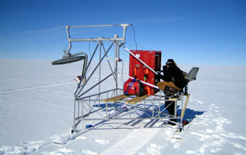
Planewave Radar System
Planewave Radar System
A 12 to 18 gigahertz Planewave Radar System operated by the Center for Remote Sensing of Ice Sheets (CReSIS) near Summit Camp, Greenland. The radar is mapping near-surface snow accumulation layers in the Greenland Ice Sheet. The radar is pulled behind a ground rover or a snowmobile, but others are in development at CReSIS that will be flown on aircraft ranging from the P-34 Orion to small, un-crewed, aerial vehicles. In this photo, researchers Tim Rink is pictured in the foreground and Dr. Pannir Kanagaratnam is behind him.
CReSIS is a National Science Foundation Science and Technology Center created with the mission of developing new technologies and computer models to measure and predict the response sea level change to the mass balance of ice sheets in Greenland and Antarctica. To learn more about the center and its activities, visit the CReSIS Web site. (Date of Image: 2005)
Credit: D. Braaten, CReSIS, University of Kansas
Images and other media in the National Science Foundation Multimedia Gallery are available for use in print and electronic material by NSF employees, members of the media, university staff, teachers and the general public. All media in the gallery are intended for personal, educational and nonprofit/non-commercial use only.
Images credited to the National Science Foundation, a federal agency, are in the public domain. The images were created by employees of the United States Government as part of their official duties or prepared by contractors as "works for hire" for NSF. You may freely use NSF-credited images and, at your discretion, credit NSF with a "Courtesy: National Science Foundation" notation.
Additional information about general usage can be found in Conditions.
Also Available:
Download the high-resolution JPG version of the image. (2.4 MB)
Use your mouse to right-click (Mac users may need to Ctrl-click) the link above and choose the option that will save the file or target to your computer.

