Multimedia Gallery
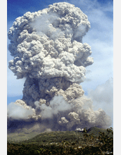
Soufriere Hills Volcano Erupting
Soufriere Hills volcano in Montserrat, where an international team of researchers has been collecting data in an effort to better understand the internal structure of the volcano and how and when it will erupt. Measurements are being taken from land and water.
More about this Image
Measurements are being taken on land and in water as part of the on-going CALIPSO/SEA CALIPSO project (Caribbean Andesite Lava Island Precision Seismogeodetic Observatory), a seismic imaging study of the structure and magma conduits of the Soufriere Hills Volcano on the island of Montserrat.
The ground-based phase of the study (CALIPSO) uses Global Positioning Systems and strain meters to measure the exact up-and-down and sideways movements of numerous points over the volcano island. The water-based phase of the study (SEA CALIPSO) uses seismic waves caused by underwater air gun explosions at sea to map inside and under the volcano island in the same way as images inside the human body are revealed by a hospital CAT scan.
In 1995, Soufriere Hills volcano began it's current series of eruptions and pauses, with each episode lasting from one to three years. The most recent eruptive period began in October 2005 and ended in April 2007, followed by a pause, which still continues, although a series of explosions started in early December 2008, and may mark the onset of the next eruptive period.
"Using land-based measurement, we can see that over the time periods when the magma is erupting, the ground surface deflates into a bowl of subsidence and when the magma is sealed underground, the ground surface inflates like a balloon," says Barry Voight, professor emeritus of geosciences at Penn State and director of the SEA CALIPSO project consortium. "The interesting thing is that much more magma is erupting than appears represented by the subsiding bowl."
The National Science Foundation (through continuing grant EAR 07-32415), Natural Environmental Research Council, UK, British Geological Survey and Discovery Channel are supporting this work. For more information, see the Penn State news story, "CAT Scan Reveals Inner Workings of Volcano Island." (Date of Image: unknown)
Credit: Barry Voight, Penn State.
Images and other media in the National Science Foundation Multimedia Gallery are available for use in print and electronic material by NSF employees, members of the media, university staff, teachers and the general public. All media in the gallery are intended for personal, educational and nonprofit/non-commercial use only.
Images credited to the National Science Foundation, a federal agency, are in the public domain. The images were created by employees of the United States Government as part of their official duties or prepared by contractors as "works for hire" for NSF. You may freely use NSF-credited images and, at your discretion, credit NSF with a "Courtesy: National Science Foundation" notation.
Additional information about general usage can be found in Conditions.
Also Available:
Download the high-resolution JPG version of the image. (884 KB)
Use your mouse to right-click (Mac users may need to Ctrl-click) the link above and choose the option that will save the file or target to your computer.

