Multimedia Gallery
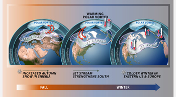
New Model for Predicting Snowfall
Researchers have validated a new weather prediction model that uses autumn snowfall to predict winter cold in the United States and Europe. When snowfall is high in Siberia, the resultant cold air enhances atmospheric disturbances, which propagate into the upper level of the atmosphere, or stratosphere, warming the polar vortex. When the polar vortex warms, the jet stream is pushed south leading to colder winters across the eastern United States and Europe. Conversely, under these conditions the arctic will have a warmer than average winter.
This image accompanied NSF press release, "Scientists Verify Predictive Model for Winter Weather."
Credit: Nicolle Rager Fuller, National Science Foundation
Images and other media in the National Science Foundation Multimedia Gallery are available for use in print and electronic material by NSF employees, members of the media, university staff, teachers and the general public. All media in the gallery are intended for personal, educational and nonprofit/non-commercial use only.
Images credited to the National Science Foundation, a federal agency, are in the public domain. The images were created by employees of the United States Government as part of their official duties or prepared by contractors as "works for hire" for NSF. You may freely use NSF-credited images and, at your discretion, credit NSF with a "Courtesy: National Science Foundation" notation.
Additional information about general usage can be found in Conditions.
Also Available:
Download the high-resolution JPG version of the image. (304 KB)
Use your mouse to right-click (Mac users may need to Ctrl-click) the link above and choose the option that will save the file or target to your computer.

