Multimedia Gallery
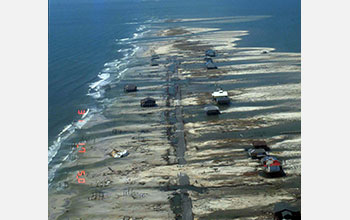
Aerial photo of Dauphin Island in Alabama following Hurricane Katrina
An aerial photo of Dauphin Island in Alabama following Hurricane Katrina in 2005. Storm surge and waves over-washed the island, destroying homes and washing sediment and debris off the island.
More about this image
Recent research by Woods Hole Oceanographic Institution (WHOI) scientists, funded by the National Science Foundation (NSF) (grants OCE 09-03020 and OCE 13-56708), has found evidence of intense hurricanes--possibly more powerful than any storms New England has experienced in recorded history--frequently pounding the region during the first millennium, from the peak of the Roman Empire to the height of the Middle Ages. These findings could have implications for understanding the intensity and frequency of hurricanes the U.S. Northeast may experience in the future.
WHOI scientists examined sediment deposits from Salt Pond near Falmouth on Cape Cod. The pond is separated from the ocean by a 1.3- to 1.8-meter-high (4.3 to 5.9-feet) sand barrier. Over hundreds of years, strong hurricanes have deposited sediment over the barrier and into the pond, where it has remained undisturbed. They extracted 9-meter-deep (30 feet) sediment cores which were then analyzed in the lab.
Similar to reading a tree ring to tell the age of a tree and the climate conditions that existed in a given year, scientists can read a sediment core to determine when intense hurricanes occurred. They found evidence of 32 prehistoric hurricanes, along with the remains of three documented storms that occurred in 1991, 1675 and 1635.
"We hope this study broadens our sense of what is possible and what we should expect in a warmer climate," said Jeff Donnelly, a WHOI scientist and lead author of a paper on the results of the study. "We may need to begin planning for a category 3 hurricane landfall every decade or so rather than every 100 or 200 years. The risk may be much greater than we anticipated."
To read more, see NSF press release 15-012, Monster hurricanes struck U.S. Northeast during prehistoric periods of ocean warming. (Date image taken: May 2005; date originally posted to NSF Multimedia Gallery: Sept. 30, 2015)
Credit: U.S. Geological Survey
Images and other media in the National Science Foundation Multimedia Gallery are available for use in print and electronic material by NSF employees, members of the media, university staff, teachers and the general public. All media in the gallery are intended for personal, educational and nonprofit/non-commercial use only.
Images credited to the National Science Foundation, a federal agency, are in the public domain. The images were created by employees of the United States Government as part of their official duties or prepared by contractors as "works for hire" for NSF. You may freely use NSF-credited images and, at your discretion, credit NSF with a "Courtesy: National Science Foundation" notation.
Additional information about general usage can be found in Conditions.
Also Available:
Download the high-resolution JPG version of the image. (546 KB)
Use your mouse to right-click (Mac users may need to Ctrl-click) the link above and choose the option that will save the file or target to your computer.

 All images in this series