Multimedia Gallery
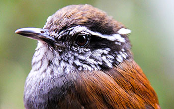
Remote-sensing data shows hundreds more species risk extinction (Image 1)
The Munchique wood wren is endemic to Columbia and was described just a decade ago. It is critically endangered and is affected by ongoing deforestation in its small habitat range. [Image 1 of 2 related images. See Image 2.]
More about this image
A study led by researchers at Duke University found that more than 200 species of birds in six rapidly developing regions are at risk of extinction despite not being included on the International Union for Conservation of Nature (IUCN) Red List of at-risk species.
For the study, researchers used remote sensing data to map recent land-use changes that are reducing suitable habitat for more than 600 bird species in the Atlantic forest of Brazil, Central America, the western Andes of Colombia, Sumatra, Madagascar and Southeast Asia. Of the 600 species, only 108 are currently classified by the IUCN Red List as being at risk of extinction. The new analysis, however, reveals that 210 of the species face accelerated risks of extinction and 189 of them should now be classified as threatened, based on the extent and pace of habitat loss documented by recent remote sensing.
While the Red List assessment is good, the researchers say it's outdated and does not make use of advances in geospatial technologies like digital maps, regular global assessments of land-use changes from satellite images and maps showing areas protected by national parks. Excluding geospatial data in its assessments means the Red List may be seriously underestimating the number of species at risk, thus causing scientists and policymakers to overlook priority areas for conservation.
For instance, while the Red List currently includes estimates of the size of a species' geographical range in its assessment process, it fails to account for how much preferred habitat remains within that range, said Natalia Ocampo-Peñuela, the study’s lead author, who received her Ph.D. from Duke in 2016 and is a National Science Foundation (NSF) grant recipient (see last paragraph). Knowing the status of a species' preferred habitat is vital for accurately assessing extinction risks, especially for species that have small geographical ranges to begin with. But it’s ignored in the current Red List assessment process, says Ocampo-Peñuela.
To learn more about this research, see the NSF News From the Field story Remote sensing data reveals hundreds more species at risk of extinction.
[In addition to being lead author of the scientific paper, Natalia Peñuela is the photographer for this image and was funded by an NSF Doctoral Dissertation Improvement grant (grant BCS 14-34281). Varsha Vijay, coauthor of the scientific paper, was also funded by NSF through the Graduate Research Fellowship Program (grant DGE 11-06401).] (Date image taken: 2014; date originally posted to NSF Multimedia Gallery: Feb. 14, 2017)
Credit: Natalia Ocampo-Penuela, ETH Zurich
See other images like this on your iPhone or iPad download NSF Science Zone on the Apple App Store.
Images and other media in the National Science Foundation Multimedia Gallery are available for use in print and electronic material by NSF employees, members of the media, university staff, teachers and the general public. All media in the gallery are intended for personal, educational and nonprofit/non-commercial use only.
Images credited to the National Science Foundation, a federal agency, are in the public domain. The images were created by employees of the United States Government as part of their official duties or prepared by contractors as "works for hire" for NSF. You may freely use NSF-credited images and, at your discretion, credit NSF with a "Courtesy: National Science Foundation" notation.
Additional information about general usage can be found in Conditions.
Also Available:
Download the high-resolution JPG version of the image. (4.8 MB)
Use your mouse to right-click (Mac users may need to Ctrl-click) the link above and choose the option that will save the file or target to your computer.

